 |
 |
 |
 |
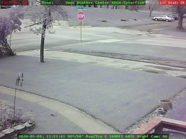
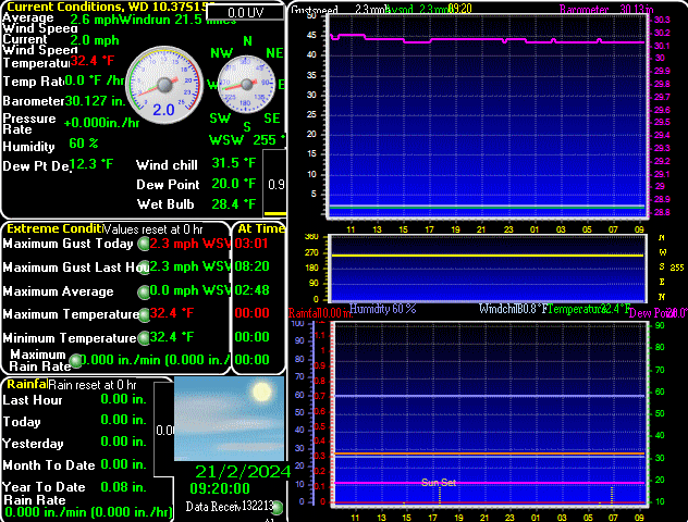
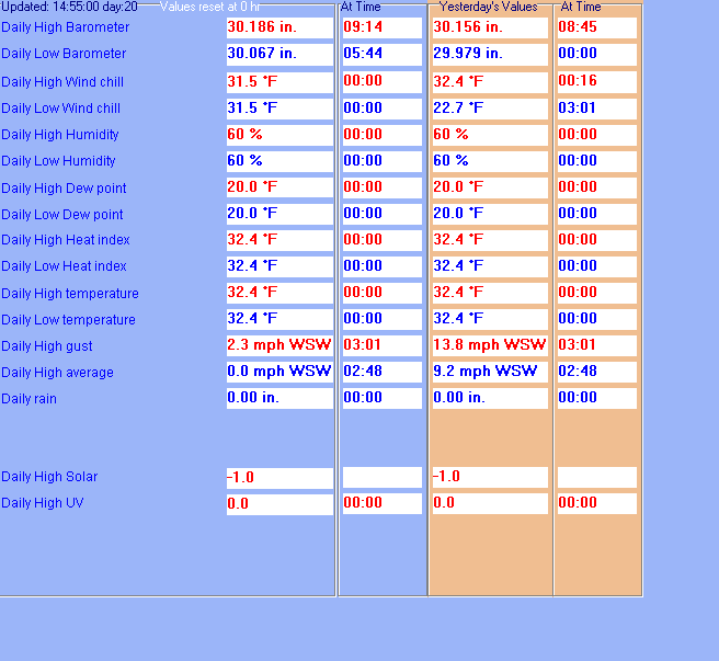
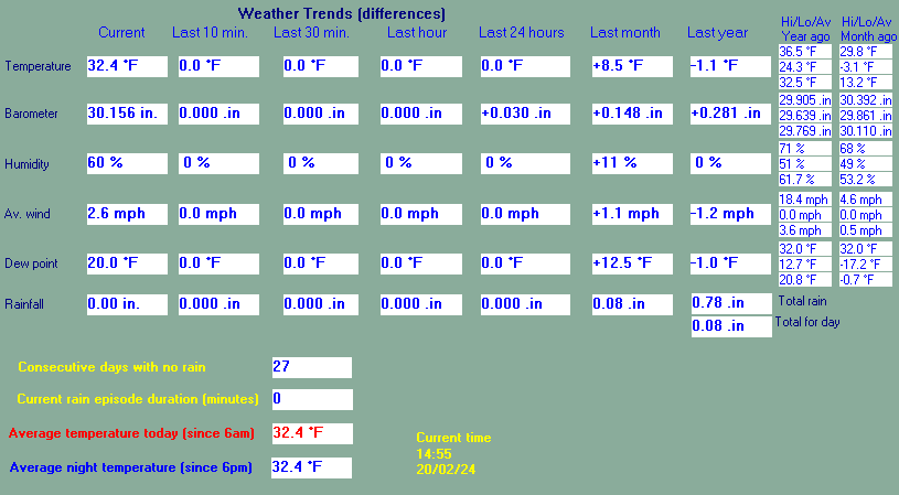
This page is updated from recent data collected by a WMR-200A UV weather station Use the Reload or Refresh facility on your browser to retrieve the latest data.
Status report of weather station: Active 24/7 Since 19:45hrs 27Dec2002
|
| ||||||
|
|
|
|
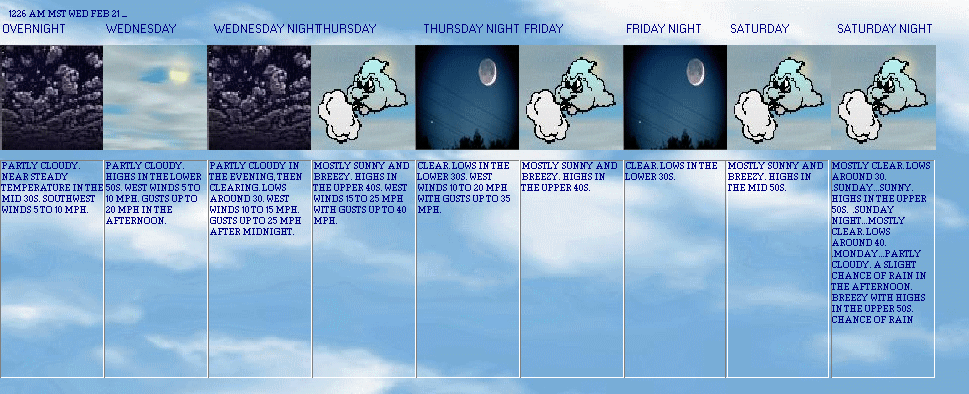
Expires:202402291200;;131834
FPUS53 KUNR 290547
ZFPUNR

Zone Forecast for Western SD and Northeastern WY
National Weather Service Rapid City SD
1046 PM MST Wed Feb 28 2024


SDZ025-291200-
Northern Foothills-
Including the cities of Spearfish, Whitewood, and Saint Onge
1046 PM MST Wed Feb 28 2024

.OVERNIGHT...Mostly clear. Not as cool with lows around 30.
Southwest winds 10 to 15 mph with gusts up to 25 mph.
.THURSDAY...Sunny. Highs in the upper 50s. Southwest winds 10 to
15 mph with gusts up to 25 mph.
.THURSDAY NIGHT...Mostly clear and breezy. Lows in the lower 40s.
Southwest winds 20 to 30 mph with gusts up to 45 mph.
.FRIDAY...Partly cloudy in the morning, then clearing. Breezy
with highs around 60. West winds 20 to 30 mph with gusts up to
45 mph.
.FRIDAY NIGHT...Partly cloudy. A slight chance of rain in the
evening, then a chance of rain and snow after midnight. Little or
no snow accumulation. Lows in the lower 30s. West winds 10 to
15 mph with gusts up to 25 mph, becoming south 5 to 10 mph after
midnight. Chance of precipitation 30 percent.
.SATURDAY...Becoming partly cloudy. A chance of snow in the
morning. A chance of rain. Breezy with highs in the mid 50s.
Chance of precipitation 40 percent.
.SATURDAY NIGHT...Mostly cloudy with rain likely. Snow likely
after midnight. Little or no snow accumulation. Lows in the mid
20s. Chance of precipitation 60 percent.
.SUNDAY...A slight chance of rain in the morning. Snow likely.
Little or no snow accumulation. Breezy, cooler with highs in the
mid 30s. Chance of precipitation 70 percent.
.SUNDAY NIGHT...Becoming partly cloudy. A 40 percent chance of
snow. Lows 15 to 20.
.MONDAY...Partly cloudy. A chance of snow in the morning, then a
slight chance of snow in the afternoon. Breezy with highs in the
mid 30s. Chance of snow 30 percent.
.MONDAY NIGHT...Mostly clear. Lows in the lower 20s.
.TUESDAY...Partly cloudy. Highs in the upper 40s.
.TUESDAY NIGHT...Mostly clear. Lows in the upper 20s.
.WEDNESDAY...Partly cloudy. Highs in the mid 40s.

$$


Spearfish / Clyde Ice, SD, United States (KSPF) 44-29N 103-47W
Feb 29, 2024 - 02:35 AM EST / 2024.02.29 0735 UTC
Wind: from the SW (220 degrees) at 22 MPH (19 KT):0
Visibility: 10 mile(s):0
Sky conditions: clear
Temperature: 41 F (5 C)
Dew Point: 19 F (-7 C)
Relative Humidity: 41%
Pressure (altimeter): 29.82 in. Hg (1009 hPa)
ob: KSPF 290735Z AUTO 22019KT 10SM CLR 05/M07 A2982 RMK AO2
cycle: 7

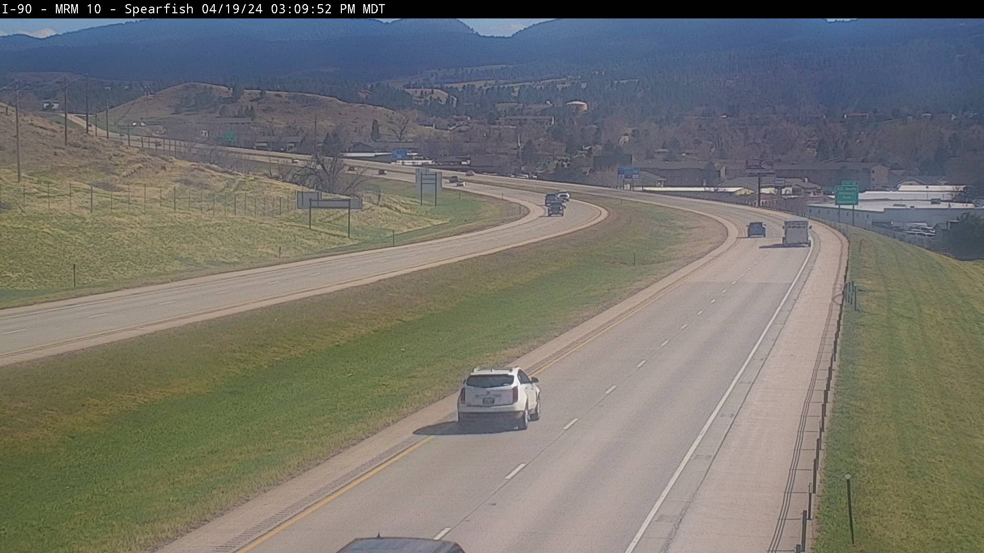
CURRENT AVIATION CONDITIONS AROUND SOUTH DAKOTA CLICK HERE
regards to their weather station or for any other matter please go to Eagle Aviation, Blackhills-Clyde Ice Airport Or
300 Aviation Place
Spearfish, South Dakota
KSPF Clyde Ice Airfield
(605) 642-4112
300 Mile Radar Provided Courtesy of Weather Underground(Ground Clutter Removed On All Radar Images)
Click The Maps To Be Taken To The Wundeground Site
Multi-Storm/Multi-Purpose Tracking Radar System with Warning Area Coverage
Spearfish Weather Up Close (Ground Clutter Removed)
Regional Radar
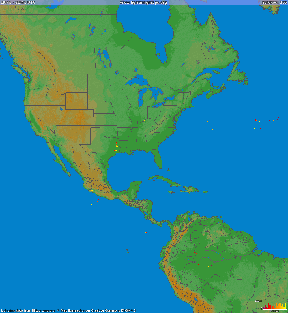
Lightning

Severe Weather Key
Lightning Detection![]()
![]()
![]() Tornadic Thunderstorm (Tornadic Vortex Signature)
Tornadic Thunderstorm (Tornadic Vortex Signature) ![]() Mesocyclone (Possible Tornado)
Mesocyclone (Possible Tornado) ![]() Hail Producing Thunderstorm
Hail Producing Thunderstorm
If a triangle ![]() is shown in this field, it indicates NEXRAD detection of a possible tornadic cell this tornado may or may not be on the ground, (this "detection" is called the tornado vortex signature)
is shown in this field, it indicates NEXRAD detection of a possible tornadic cell this tornado may or may not be on the ground, (this "detection" is called the tornado vortex signature)
Define Mesocyclone: ![]() A mesocyclone is a vortex of air, approximately 2 to 10 km in diameter (the mesoscale of meteorology), within a convective storm. That is, it is air that rises and rotates around a vertical axis, usually in the same direction as low pressure systems in a given hemisphere. They are most often cyclonic, that is, associated with a localized low-pressure region within a severe thunderstorm. Such storms can feature strong surface winds and severe hail. Mesocyclones often occur together with updrafts in supercells, where tornadoes may form. Mesocyclones are believed to form when strong changes of wind speed and/or direction with height ("wind shear") sets parts of the lower part of the atmosphere spinning in invisible tube-like rolls. The convective updraft of a thunderstorm is then thought to draw up this spinning air, tilting the rolls' orientation upward (from parallel to the ground to perpendicular) and causing the entire updraft to rotate as a vertical column. Mesocyclones are normally relatively localized: they lie between the synoptic scale (hundreds of kilometers) and small scale (hundreds of meters). Radar imagery is used to identify these features. An area of vertical atmospheric rotation in supercell thunderstorms, which signals the threat of a possible tornado.
A mesocyclone is a vortex of air, approximately 2 to 10 km in diameter (the mesoscale of meteorology), within a convective storm. That is, it is air that rises and rotates around a vertical axis, usually in the same direction as low pressure systems in a given hemisphere. They are most often cyclonic, that is, associated with a localized low-pressure region within a severe thunderstorm. Such storms can feature strong surface winds and severe hail. Mesocyclones often occur together with updrafts in supercells, where tornadoes may form. Mesocyclones are believed to form when strong changes of wind speed and/or direction with height ("wind shear") sets parts of the lower part of the atmosphere spinning in invisible tube-like rolls. The convective updraft of a thunderstorm is then thought to draw up this spinning air, tilting the rolls' orientation upward (from parallel to the ground to perpendicular) and causing the entire updraft to rotate as a vertical column. Mesocyclones are normally relatively localized: they lie between the synoptic scale (hundreds of kilometers) and small scale (hundreds of meters). Radar imagery is used to identify these features. An area of vertical atmospheric rotation in supercell thunderstorms, which signals the threat of a possible tornado.
If a yellow-filled square ![]() appears, the storm has a good chance of containing large hail. Click the above map to find out.
appears, the storm has a good chance of containing large hail. Click the above map to find out.
WARNING:IF ANY OF THESE SIGNATURES APPEARS ON THE ABOVE RADAR, SEEK SHELTER IMEDIATLY, INSIDE A STUDEY STRUCTURE, STAY AWAY FROM WINDOWS, AND DO NOT GO OUT IN THE STORM. IF A TORNADIC OR MESOCYCLONIC ICON APPEARS NEAR YOUR LOCATION SEEK SHELTER WITHIN A BASEMENT, IF A BASEMENT IS NOT AVAILABLE SEEK SHELTER IN THE INNER MOST PART OF THE STRUCTURE (AN INTERIOR BATHROOM OR BEDROOM WITH THE LEAST AMOUNT OF WINDOWS AND PUTS THE MOST WALL BETWEEN YOU AND THE STORM), IF YOU ARE IN A MOBILE HOME, OR AUTOMOBILE ABANDON THEM AND SEEK SHELTER IN A STURDY STRUCTURE (TYPICALLY A STORM SHELTER), DO NOT SEEK SHELTER UNDER HIGHWAY OVERPASSES THIS OFFERS NO PROTECTION WHATSOEVER; YOUR CAR ALSO DOESN’T PROVIDE PROTECTION. IF A STRUCTURE IS NOT AVAILABLE LYE FLAT IN A RAVINE OR LOW DITCH, COVERING YOUR HEAD AND NECK. AS WITH ANY STORM STAY AWAY FROM WINDOWS AND TREE'S AVOID GOING OUTSIDE TILL THE DANGER HAS PAST. FLASH FLOODING CAN OCCUR WITHOUT WARNING FROM A HEAVY THUNDERSTORM, AND THE THUNDERSTORM DOESN'T HAVE TO BE OVER YOU TO CAUSE FLASH FLOODING DOWNSTREAM. DO NOT WALK THRU MOVING WATER. SIX INCHES OF MOVING WATER CAN MAKE YOU FALL. IF YOU HAVE TO WALK IN WATER, WALK WHERE THE WATER IS NOT MOVING. USE A STICK TO CHECK THE FIRMNESS OF THE GROUND IN FRONT OF YOU. DO NOT DRIVE INTO FLOODED AREAS. IF FLOODWATERS RISE AROUND YOUR CAR, ABANDON YOUR CAR AND MOVE TO HIGHER GROUND IF YOU CAN DO SO SAFELY. YOU AND YOUR VEHICLE CAN BE QUICKLY SWEPT AWAY. DO NOT COME OUT OF YOUR SAFE PLACE UNTILL THE ALL CLEAR HAS SOUNDED OR SUFFICIENT TIME HAS PASSED FOR THE STORM TO COMPLETELY HAVE PASSED, ALWAYS KEEP A NOAA RADIO WITH FRESH BATTERIES, AND OR A RADIO TUNED TO LOCAL CHANNELS HANDY TO LISTEN IN ON NEWS REPORTS INCASE THE ALL CLEAR SIRENS WERE TAKEN DOWN OR DAMAGED IN THE STORM. THOSE WHO HEED THESE WARNINGS WILL TELL YOU IT WILL SAVE YOUR LIFE. THERE IS NO SUCH THING AS BEING TOO PREPARED.
For Further Information and Definitions Goto Tmax Weather Center Definitions Page
Your 5 Day Forecast
Current U.S. Surface Maps
Check your Area with this Map
US Severe Weather Map
Click on a colored region of the map for details.


Earthquake 2018
State By State Information
Earthquake 2019
State By State Information
Earthquake 2020
State By State Information
Earthquake 2021
State By State Information
Earthquake 2022
State By State Information
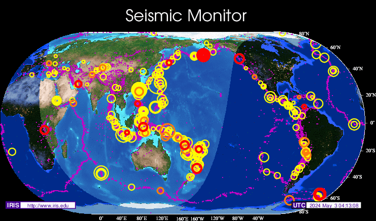
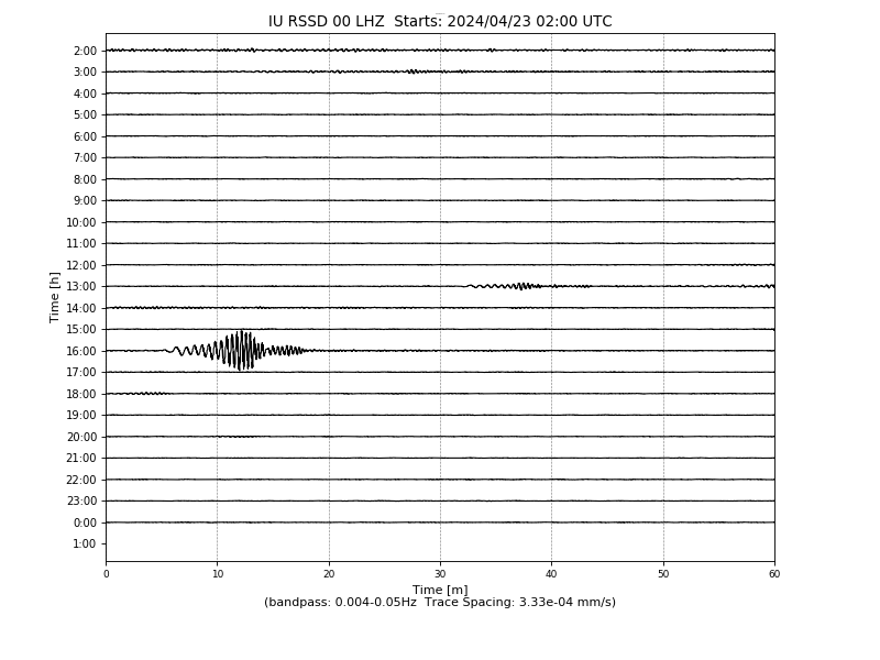
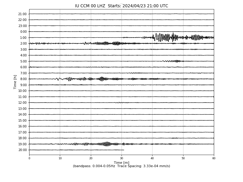
Current Geological Activity Data from station RSSD (Black Hills, South Dakota, USA)
Current Time/Date: (This is local to where you are)
Subtract 6 Hrs to get Local Standard Time, and 7 hrs to get Daylight Savings time Corrections
Current Geological Activity Data from station LKWY-Lake Yellowstone (Wyoming, Yellowstone YVO, USA)
Current Geological Activity Data from station ANTO (Cathedral Cave Missouri, New Madrid Seismic Zone, USA)
If you would like to see if there is a seismic station near you goto the following address and search for one close to you then click its seismorgram.
USGS Live Seismic Server Data Server
Please note: When you see a ground shaker on this data map, it does not necessarily indicate a seismic event has occurred here, this graph picks up events from great distances away, this is how they confirm a seismic events magnitude, by gathering information from many stations that pick it up, this tells them how far the event traveled, was felt, or was recorded. You can follow this address for a history of South Dakota Earthquakes Here There have been 85 recorded earthquakes with epicenters in South Dakota. The most recent was Saturday, November 19, 2011 at 01:28:09 AM (MST) - Mountain Standard - Local Time at Epicenter, 43 km (26 miles) S of Hot Springs, South Dakota Location 43.044°N, 103.543°W in Fall River County near Ardmore, South Dakota on the Nebraska/South Dakota border. It registered 2.8 on the Richter scale was at a depth of 4.9km and there was no damage reported or observed, the last 3 events were recorded within a small geographical area, the last 2 were most likly aftershock events.
World Wide Earthquake Information
Tmax Weather Center Sensor
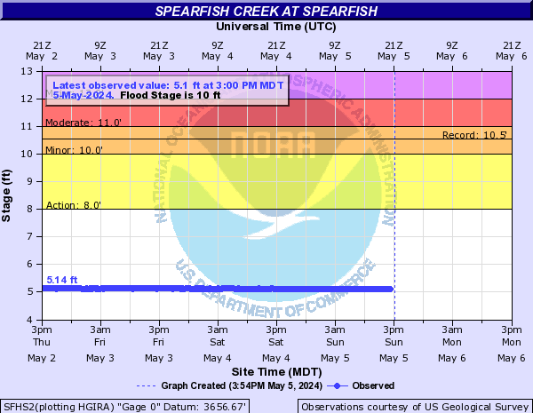
Spearfish Creek Advanced Hydrologic Prediction Service Courtesy Of

Current Disaster Information Local and International National Association of Radio-Distress Signalling and Infocommunications Emergency and Disaster Information Services (EDIS)

World Wide Pandemic Alert Level is Currently :::Extreme::: There are current outbreaks in progress
Please note: When you see information on the above disaster maps it doesn’t mean it is occurring at present or in real time, it can sometimes takes days for a disaster to take place, and or a disaster will occur then have after effects that last for some time, therefore you will see the disaster over several days and not just at once. This information is provided as is without any warranty to accuracy or timeliness, and does not constitute a general contract with Tmax Weather Center or its Affiliates. TMWC was asked to carry this site to keep you informed of worldwide disasters in progress, and makes no claims otherwise. With recent outbreaks of disease, a pandemic alert level link has also been added for your convenience. Simply click the links on above to learn about any of the world wide incidents. Above all else
DO NOT PANIC:This information above is being brought to you as a courtesy, this does not mean there is necessarily an emergency, this does not mean a disaster occurred near you, or that your sick, or will become sick, and this does not mean the illness will even be present in your area. The above levels are for informational purposes only. If you feel sick, it’s always best to seek your doctor’s advice, if you are sick stay home, if your child is sick keep them home from school. Please pay attention to local news sources and other media outlets for more information.
Dynamic Name Server®
FTP Server®
Weather Display32 (Primary Weather Collection Program)
WEATHER UPDATE SCHEDULE:
This weather station is connected directly to the internet, updates occur every 3 seconds for the live applets, and every 1 minute for the rest of the page. Please check the web page often or press refresh on your browser for the latest conditions, also you may leave this page open it is equipped with an auto-refresh, which occurs every few minutes from the time of load. However during storms, severe weather, please login, look at what you want then log out, it would be greatly appreciated due to the immediate user level load factor. This station is operational 24 Hrs a day, sometimes updates are missed due to programming changes, but no changes shall take place during an active warning or severe weather event (unless emergency steps are required). Updates to the programming shall occur on non-event weather days.
NOTE: PRECIPITATION OFFSET
During the Winter Months, precipitation amounts may be off due to freezing conditions, and or the rain gauge fills with snow and it doesn't melt till a later time. So be patient eventually all rain information will correct itself. Also the humidity and dew point may be off due to the extreme temperature changes we experience in this location, the sensor gets covered with frost due to high humidity and extreme low temps and stops reading totally. The temperature/humidity sensor since it is 90% exposed, is vulnerable to these conditions. The temperature reads accurately. As the temperatures approaches up to the freezing point the sensors become operational. Sorry for this, there isn’t much I can do about Mother Nature when she decides to freeze something. Also Mother Nature in her cruel irony, has decided to give us lots of ice from time to time, so I have found out the anemometer (wind gauge/wind direction) can get ice covered/snow covered and also stops reading, argh got to love it? NOT! Also of note, measurements from this weather station are done on a tilt bucket rain gauge, do not be fooled by anyone that says they aren't accurate, they as they are just as accurate as any rain gauge currently available, don't be fooled by these advertisements about this rain gauge is better than that one, It’s just hype, so even that little cheapy you get at the local farm market is 99.99% as accurate as the professional gauges. They all measure rainfall, also note that even a rain gauge 10 feet away from yours could measure a different amount of precipitation simply because precipitation does not nor has it ever fallen 100% evenly over any given area on this planet, so don’t fall for anyone yanking your leg. If someone says they are better than the rest, ha ha they are "all wet!"
NOTE: MEASURE SNOWFALL PROPERLY
Measuring snowfall by "inches" is very dependent on the density of the snow, and the freeze thaw cycle compounds the uncertainty, and of course drifting has a big effect. The rough rule of thumb is that the ratio of snow to water is a 10 to 1 Ratio. Simply 10 inches of snow = 1 inch of liquid precipitation. You can use a ruler to measure snowfall as it comes down, but the complication behind that is simple, snow melts on impact with warmer ground till the ground cools down, therefore the total will be off. This station uses a liquid measuring system, as the snow falls into the rain gauge it is melted by a low-level heat source, and it measured as liquid precipitation. Also certain times the temperature is so cold that even the low level heat source does not melt it right away. Since snow is of different densities, and different moisture contents when it falls, liquid measurements are the only truly accurate representation of total true amount of snow that has fallen, even though there may seem to be much more on the ground then the rain gauge says there is. For example, a storm in late February 2004 dropped 24.1 inches of ruler measured snowfall on us, but once liquefied it measured just a little over an inch of liquid precipitation. Does that mean we only got 10 inches, no, but one thing it does prove, measuring with a stick, and measuring with a rain gauge are two very different means by which to do it. Doesn't make shoveling it any less of a headache, nor driving in it any less hazardous. Just remember perceptions of snow, and actualities of snowfall are very different. Just because it looks like a lot, doesn't mean there is a lot. Also of note: This varies with different kinds of snow, and some snows are characterized as "wet snows," and some as "dry snows." The water equivalent of wet snows may be as low as 6 or 8 to 1. This means 6 inches of snow equals one inch of liquid. A dry snow may have a ratio of 20 to 1, or even as high as 50 to 1 in very cold arctic regions. This means it would take 50 inches of snow to equal one inch of liquid. So you decide it's all a matter of perception, and precipitation.
Mission Statement :
"To provide 24 hour meteorological, oceanographic, geological, and space environmental information, products, and services that are relevant to the City, State and Federal Agencies indicated throughout this website, to assist their operations and any other operation as may be directed by Local, State, or Federal agencies. We strive to be an accurate resource for South Dakota Climate & Weather, providing data to Private, Agriculture, Industry, Education, and the General Public as it relates to our local Community and the State. As soon as we receive new information, we pass it along to you so that you are always informed of what's going on in the world of weather, 24 hours a day, and 365 days a year. This site contains detailed weather forecasts provided by our staff and other meteorological source. In addition, we have links to many weather products from various weather forecasting agencies, and we provide all of this free of charge with no prejudices. Whether you know it all, or know nothing, we here at the TMWC are here to serve you, the community."
****WEATHER IMAGE OF THE DAY****
I have decided to put up a Weather Picture Gallery for you at Image of the day Enjoy some of the weather pictures I have up. Thanks
****Oregon Scientific WMR-200-A UV Weather Station Fix****
I have decided to put up the fixes for the weather stations I use, at Oregon Scientific WMR-200a UV Please read carefully if implementing any of these fixes.
Barometric Pressure
Want to know what your barometric pressure is corrected for your elevation above sea level, well we got it for you, go to Barometric Pressure Adjust page and check it out.
DISCLAIMER:
Never use information provided on this or any other web site for the protection of life or property. When severe storms are occurring in, or threaten your location, tune to your local NOAA NWS weather station or a local radio or TV broadcaster in your area for immediate weather information. Weather information is provided without warranty of any kind as to accuracy or timeliness, and should never be used to make decisions during a weather emergency.
ATTENTION: WEATHER WATCHERS
Lawrence County Residents, would you like weather alert email sent directly to your inbox, contact us at Tmax Weather Center Keep up to date on the latest information, alerts, and warnings for your area. Please include your name and general geographic location so I know I am downloading the proper reports for your area. Please make sure to allow this thru any spam filter, and or firewall, if you are a returning member, please make sure you have no blocks against this address, or you will not receive the emails. You can also get weather from NOAA Weather Radio on Station :
TERRY PEAK near Lead, SD: WXL-23 on 162.525 MHz serves the Northern Black Hills :
 |
NOAA Live Weather Radio WXL-23 NOAA/NWS Rapid City/Lead, South Dakota is provided by the National Weather Service in Rapid City, South Dakota, and is only re-broadcast by The Tmax Weather Center Station. Tmax Weather Center has no control over maintenance, downtime, personnel or complaints towards NOAA or NWS, if you have a complaint to file please follow this address related to the weather radio. NWR Transmitter Problems and file your complaint there. The automated contact number is just that automated. If you contact Tmax Weather Center we will do our best to forward those emails but no guarantees. Tmax Weather Center will cease carrying this signal on January 1, 2012. This is mainly due to the constant static and interference from an underpowered machine, and lack of support in either upgrading the equipment or giving the signal a bit of a boost. WXL23 on Terry Peak boasts 300watts of transmit power, however that doesn't even get it to me 13.7 miles away. I can transmit around the world on 1watt given the right equipment. Other stations have either 700 or 1000 watt transmitters, and man can you hear those babies and it's usually over top of the station you want to hear due to frequency bleeding from the more powerful station. I can listen to weather in 2 other states because of it and I consider that a threat to me and to my family and neighborhoods and will discontinue to be a part of a system that propagates a signal that is nothing more than static on a bandwidth. 90% of the time you can't even hear the signal from WXL23. I cannot afford larger receivers nor larger un-attractive antenna's. So I am telling you all now, you need to get a weather radio for your personal use however I can make no guarantee to its effective use based on the information I have provided here because of the signal issue and lack of interest in proper broadcasting.
If you have general complaints, or would like to contact them goto NOAA/NWS Contact
If you would like to write NOAA/NWS and you can even write them for non-complaints or just to ask a question. If you have a complaint, or problem regarding a local office I suggest you contact the Primary NOAA office at the US Department of Commerce, as local offices (but not all offices) are not generally helpful in answering your complaints.
National NOAA/NWS Offices
US Dept of CommerceNational Oceanic and Atmospheric Administration
National Weather Service
1325 East West Highway
Silver Spring, MD 20910-3283
WHY THE PERSONAL WEATHER STATION
In recent years Mother Nature has dealt a rather nasty hand on many occasion. The PWS or Personal Weather Station is coming into its own now and it’s growing daily. There are more stations coming online every day, that are covering in places not already covered by the NOAA’s National Weather Service, or the USDA, even the USGS whom at this point seem to be outpaced by Mother Nature. Our little PWS’s fits the bill in areas or lack of interest in an area to a Tee! We tend to cover where they won't, or we cover an area they cover simply because we do not trust the forecast they give. We are private citizens with the time, energy, resource and location to put up our own little monitoring stations. A meteorologist is a specialist and or person who studies processes in the earth's atmosphere that cause weather conditions. You can look up the many definitions for it on the World Wide Web. We do not have to do this job we are doing; we don’t and aren’t required to do so by law, and usually no one asks us to do it either. These stations are not cheap, so we don’t take this as lightly as some may think. I have been in consistent operation since December of 2002, and have not had downtime, with a few small exceptions like software updates, or hardware crashes, or unavoidable situations, but my data is solid, accurate because I have a friend of mine from MIT calibrate them, believe me they are dead on accurate. He does it every January! So I dispute anyone that would say my data is incorrect. I have been monitoring weather since I was a kid. I have watched it from more perspectives then just a professional standpoint. I was a farmer’s son, I watched my father predict the weather just by the feel of the air outside. It was fascinating to see. For years I thought he was just guessing, but after years and years and years of accuracy and me watching, he was 99% accurate out to about 3 days. Simply based on temperatures, the barometric pressure, and how damp it was he could give 72 hrs worth of useful forecast. It doesn’t take a trained spotter, an employee of the NWS or member of a government or political agency, nor does it take anyone other than the average "Joe" citizen to simply go outside and look up, to tell you what the weather is, being trained in no way makes you qualified, nor does not being trained make you qualified, and quite often the so called “unqualified” of "us" has more skill sets then we know what to do with. Welcome to the Tmax Weather Center Operations Headquarters, Spearfish, SD 57783/57799 and if you have any questions related to weather, you can contact me and I will do my best to answer them for you, or direct you to those that can. I may not be an "expert", but at least there are some things I will guarantee you, NO BS, I have an open mind, and I will give you no rude attitudes! Like it or not "Mother Nature" we are here to stay!

Only You Can Prevent Forest Fires(click the badges to be taken to the information.)
COOPERATING AGENCIES Northern Great Plains Interagency Dispatch Center Dispatch Hours 0730-1730
The Fire Weather Index as Generated by The Tmax Weather Center is in the live applet near the top of this page! This Station produces this image from the raw data it collects it is not representative of the images above provided by the Northern Great Plains Interagency Dispatch Center.

4250 Fire Station Rd. Suite 2
Rapid City, SD 57703-8714
605-393-8017
Fax 605-393-8030
COOPERATING AGENCIES LINKS
National Oceanographic & Atmospheric Administration //National Weather Service //NOAA / Space Weather Prediction Center//
Weather Display //Weather For You //Ham Weather Radio //
Citizen Weather Observer Program(CWOP)//Anything Weather //United States Geological Survey//
South Dakota School of Mines & Technology, Institute of Atmospheric Sciences //Blackhills.Com Internet Services //National Geographic //
National Association of Radio-Distress Signalling and Infocommunications //AWS Weather and Dept. of Homaland Security //AWS Weather Inc. //
Rocky Mountain Weather Network(RMWN)//Plains Weather Network(PWN)//Weather Underground//
National Aeronautics and Space Administration (NASA)//Skywarn//United States Weather Group//Yowindow Weather Station & Screen Saver//
Other Links
Federal Organizations and Resources
Department of Homeland Security //Ready.gov//
FBI Tips and Leads//
Most Wanted Terrorists//A Citizens Guide to Preparedness//
Community Emergency Response Teams//
Citizen Corps//USA Freedom Corps//First Gov//
Disaster Help//Medical Reserves Corps//Volunteers in Police Services//
Voluntary Service//Nieghborhood Watch Program
Notice To Viewers
2011 the worst Tornado Season ever, our thoughts go out to those who have been lost, and those who lost someone. Please, Please pay attention to the weather around you, it can change in less then 5 minutes from sunny to twister, if you see bad weather coming seek shelter, if you hear the sirens get into a basement, low ditch, or storm cellar, do not remain outdoors. Flying debris, large hail, unexpected high winds, and lightning or flash flooding can get you with little or no notice. Be mindful that flooding can occur even 24 to 48 hrs after a storm. Lightning can strike up to 10 miles in any direction of the main storm cell. Hail will kill you it's moving at 100+ mph... High winds can blow your vehicle off the road, knock over structures your in or around, so seek sturdy shelter.Stay away from windows, or any glass, get into a room with as much distance between you and the outside walls as possible. Do not take a shower, bath or wash your hands during a thunderstorm, do not talk on a phone that has a chord to the earpiece. Do not stand under large structures of metal or tree's, and if your playing golf get the hell off the course. Do not emerge from your safe place till the all clear sounds or the sounds of the storm have diminished, it takes longer then 5 minutes for a storm to pass so stay put for no less then 30 to 45 minutes.Get a NOAA weather radio with audio/visual alert systems, and make sure it has battery backup. Keep a radio, and enough supplies for 72 hrs in your safe zone for each person there. When your told to get out,get out, don't think your going to live thru it everytime. Your not going too! Follow law enformcent and or emergency personel requests, advice, and or commands. If you want to help, follow orders of the incident commander or the person in charge. DO NOT BREAK THE LAW! If you have none of the above shelters,get into the bathtub, cover yourself with as much protection as possible, make sure its a central room if possible. If it has doors close and lock those doors if possible, and as above avoid windows. If you are thrown, tossed or otherwise, curl into a ball and protect head and neck.If you are in a high rise building or buildings with more then 1 floor, head for the center of the building. If you are caught outside get inside. Do not go outside right away after the storm falling glass and building materials may fall on you causing serious injury.Serving Spearfish, and Surrounding Communities, With Fast, Accurate and Up To Date Weather Data.
Serving The World, by supporting Charities, like the following, Make your Donations today.
St Jude Childrens Research Hospital and Country Cares for St Jude Kids.

This Station Is a Country Cares station. Visit them on the web, facebook, and listen to them live.
Month By Month
Weather Information
United States Amber Alert System:
National Homeland Security Knowledgebase
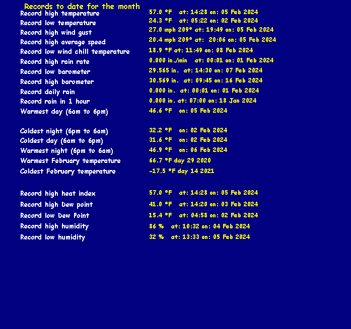
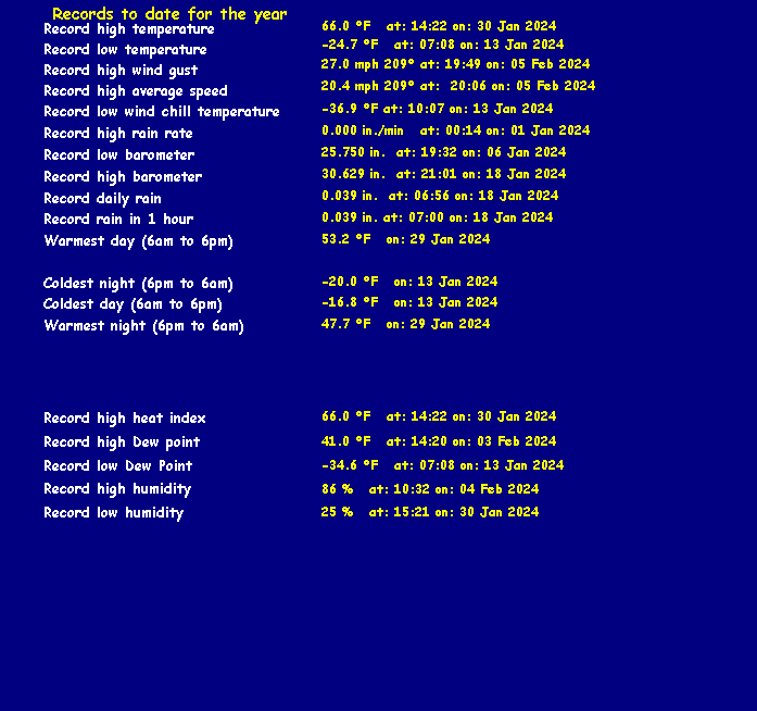
Click here for a daily update of the averages/extremes to date for the month
You are Visitor
To the Tmax Weather Center![]()
Seattle assisted living
There have been 1,755,574,395 visits to this page since December 27, 2002
Updated January 01, 2020 12:00:02 Hrs
Powered By

Protected By

Find Us On

Tmax Weather Center (TMWC) is a Non-Profit Public Service weather access point and is run solely on volunteer services.
Send mail to Tmax Weather Center with comments about this web site.
Copyright © 2020 Tmax Weather Center
All materials contained on this site are protected by United States copyright law and may not be reproduced, distributed, transmitted, displayed, published or broadcast without the prior written permission of Tmax Weather Center
You may not alter or remove any trademark, copyright or other notice from copies of the content.
Last modified:


Known Compatibility Issues: None, Thanks and enjoy the site.
This Page Currently Compatible with the the following,
Microsoft Internet Explorer : AOL Netscape Navigator/Explorer : Mozilla Firefox : Google Chrome : Verizon Novarra : Mozilla SeaMonkey : Apple Safari : Opera
Please contact the webmaster should this page or any other not load properly on the browser you are using. If you have issues please contact me regarding the error.